
Geography students win awards and connect with alumni in Ohio Geographical Information Systems conference

Written by Julia Plant, CAS communications intern
Four students from Miami's Department of Geography participated in the annual Ohio GIS (geographic information systems) Conference hosted by the Ohio Geographically Referenced Information Program in Columbus, OH from September 24–26.
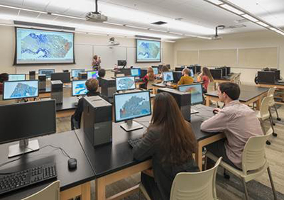
Students working in the Department of Geography's Geospatial Analysis Center.
This year for the first time, students who wished to participate in the conference, whose theme was "GIS Matters," were offered full support. The department coordinated travel, helped with any missed classes, and covered all travel, lodging, and conference submission expenses.
Participation came from professionals, academics and students. Miami's 4 student participants were Meg Jones (urban & regional planning), Ian Berg (urban & regional planning; mathematics), Austin Jenkins (geography), and graduate geography student Meghan Jones.
"During the conference, I was able to see the variety of applications that GIS is being used for across the state and was able to meet Miami alums and others who apply GIS day-to-day in their careers," said Berg.
Few Miami students had participated in past years, but this is the largest turnout the department has had in a single year.
"We were a lot more coordinated and intentional about it this time," said Robbyn Abbitt, GIS coordinator in the Department of Geography and presenter at the conference.
Students had the option to enter a digital or physical mapping presentation.
Berg won first place in the student category for his map presentation, "Tracking Arrival-Reporting Rates of Cincinnati's Firefighting Vehicles at Structure Fires."
Meghan Jones took second place for her presentation, "Scoring Butler County Parcels for Strategic Conservation Planning."
Students had the chance to interact with Miami alumni and professionals in the GIS world. They collaborated with geographers using cutting edge technology and had the opportunity to network with professionals in their field. A number of these professionals were Miami alumni.
"It was exciting to learn more about what my future career could look like and attend seminars on new technologies I had not seen," said Meg Jones.
The 3-day conference included a full day of workshops for attendees to get hands-on experience in mapping.
"Attending a conference like this that combines both professionals and academics provides students with an interesting opportunity to showcase the work that they're doing and also interact with local Ohio GIS professionals," said Abbitt. "They're given a window to what the professional world looks like."