
New map, new look: Cartography and teamwork at Miami

by Elizabeth Jenike, IT Services
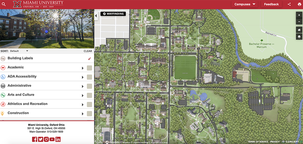
If you haven’t yet, go check out the new Miami University interactive campus map: MiamiOH.edu/map.
Cool, right?
How does something like this come together? What are the advantages of having a real-time campus map? This was an undertaking that required a lot of hands in the cookie jar—and a good amount of teamwork. Thanks to collaborative efforts from University Communications and Marketing, Finance and Business Services, and the AccessMU Center, the new map is fresh, modernized, and—this is a big one—easier to update!
Much more accessible than a PDF
Web content accessibility specialist Laura Fathauer and her army of student employees from the AccessMU center were involved from a technical aspect—it’s her office’s responsibility to determine the accessibility of the new technology tools acquired by the University. Using Level Access Assistant and other automated accessibility tools and checkers, she and her students ran tests on the map product before any contracts were signed.
“We compiled the results from running these tools,” she said. “But the thing is—even the best tools can only verify about 30 percent of the accessibility of anything you’re checking. Sometimes it’s 25 percent, sometimes 50 percent—although I’m skeptical of that number.”
The remainder, she said, needed to be checked manually.
She and her team of students tested the color contrast ratios of the text and background elements and did keyboard testing. For instance, when using the tab key to move through the page, there is a visual indicator that shows the current focus location, and some checkboxes were missing this indicator. The Physical Facilities Department also physically sent staff members around to verify the locations of accessible building entrances to provide text descriptions that will appear in the text-only version of the map.
After testing, Laura and accessible technology specialist Nick Laes from the AccessMU center provided the findings to the vendor. The AccessMU center is still working with the vendor on some of the issues they’ve identified, but overall is positive about the experience. It’s a dynamic relationship, important in staying abreast of the needs of our faculty, staff, and student populations.
Coming soon…
In addition to providing an up-to-date wayfinding experience for current residents of the University, there are some potential advantages to the new online map.
Right now, as the tool has only really covered the transition from paper to online, the map can do the basics: It shows where the buildings are (updated and in the right areas); the map has been flipped to more accurately reflect the cardinal directions (i.e., the top of the map is now pointed north, whereas it had been pointed west in the previous document); and it provides some wayfinding capabilities.
In the future, the list of potential benefits and capabilities of this map are virtually endless. According to Brad Grimm, assistant vice president and chief information officer, Finance and Business Services, Miami is also looking at adding heat maps for parking lots, so that travelers will be able to identify whether or not there are free spots in the places they need to park; there is the possibility of integrating with city buses to provide real-time location and route updates. They’re even considering integrating with the Milestone camera system on campus so that folks would be able to see a count of how many people are in line at Starbucks and see if it’s worth the wait!
“The physical map was getting out of date, and it was getting harder and harder to update,” Grimm said. “My role was to help identify an online tool that would get us off of paper and provide additional engagement opportunities and functionality, and that would be accessible as well. It was a lot of work for the entire team, but thanks to the leadership of Paul DiBenedetto on my team, Rick Costello in Physical Facilities, the University Communications team, as well as the AccessMU team, we were able to meet some very aggressive timelines. In addition to the hard work the entire team at Miami put in, our vendor has also demonstrated their willingness to be a great partner and have been incredibly responsive to our requests.”
“This campus map initiative is a great example of what we can accomplish (and how fast we can accomplish it) when we successfully partner across organizational boundaries.”
“It was a win-win for everybody.”
Check out the new map at MiamiOH.edu/map.
For more information about the new interactive campus map, see the announcement from Miami!