

New map of Miami Middletown pushes seamless technological culture
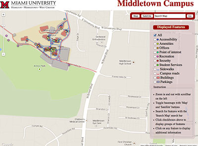
A new interactive web map of Miami Middletown highlights buildings, offices and services.
written by Trevor Jordan, university news and communications intern
Recent Miami University graduate Aaron Smigielski and Ziying Jiang, assistant professor of geography, collaborated over three semesters to develop an interactive web-based map of Miami Middletown with hopes of helping students, faculty and staff locate and utilize campus services more effectively.
From parking spaces to student services, users are able to sift through over ten layers of displayable features on the map. Once a layer is selected (i.e. “Student Services”), users can click the corresponding item that appears on the map to learn more about that specific feature and what it looks like.
Smigielski, who has a dual degree in integrative studies and geographic information science, believes that this immersive interaction is an essential step beyond the traditional map format.
“The original Middletown map is just a PDF of the buildings and roadways, with a small list of major departments and no indication of their location,” he said. “That’s what’s cool about mapping things on an interactive micro level; we eventually want to have not only a picture of a building, but a floor plan as well, showing where such offices, stairwells and doors are located.”
A secondary goal of the map is to get students more involved on campus and utilize available resources. To do so, the map provides descriptions and pictures at each point.
“In the practical sense, our map displays a lot of student services that I think are underused on campus,” said Smigielski. “Giving them an interactive map where they can locate these services and learn about them is a great way to get more students involved.”
The development of an interactive map is part of a larger goal of Jiang’s to help Miami set up a “Smart Campus,” one that provides useful technological geographic information at every corner. It would help individuals make quicker, smarter decisions with seamless interactions between technology and themselves. Such a campus would provide a cost-effective approach to a variety of areas, including student recruiting, emergency preparedness and response, and facilities management, said Jiang.
Although the development of the preliminary coding only took about 20 hours, the design of the actual interface and creation of transparency between each system extended the project over three semesters.
“Creating the actual display – the building shapes and dots/lines on the maps – that stuff’s not easy, and you have to tune it so it’s accurate,” said Smigielski. “Making it interactive and getting each of these systems to work together, that’s where it takes the most patience and a lot of learning.”
The aesthetic shell of the map was created using Google Maps Application Programming Interface (API), which allows users to construct their own map design in concordance with Google’s location data. The database side, however, was coded using Google fusion tables, which is like an Excel file with more applications, said Smigielski. That’s where the data is stored and what actually renders the map layers and shapes.
Although Smigielski has graduated, Jiang is determined to have maps developed for both Miami’s Hamilton and Oxford campus. With a project of this magnitude, more people would need to contribute, said Jiang.
“I would love to push this project to the Hamilton and Oxford campuses, but it would require a larger, specialized team of people,” she said. “There are many steps to this process, and it’s just not realistic to rely on a two-person team.”
With a larger team, design and focus, the prospective interactive maps would venture far beyond getting someone from point A to point B. Both Smigielski and Jiang agree that these maps would become, and spark, Miami culture.
“I think the maps would help increase the students’ sense of community and identity as a Miamian,” said Jiang. “There are a lot of possibilities and many ways we can use this campus map; not only as a practical function, but also just as a feeling, an emotion – you feel more attached to the campus if you get more familiar with it, and your memory of your college life will become more colorful.”
“I like the idea of – as it grows – other students adding to it to make it their own,” said Smigielski. “I am very hopeful that one day it will be this giant network of apps with people uploading information to it. That’s something that I think could really impact Miami’s culture.”
To use the interactive Middletown map on your PC, smartphone or tablet, visit www.regionals.miamioh.edu/webmap.